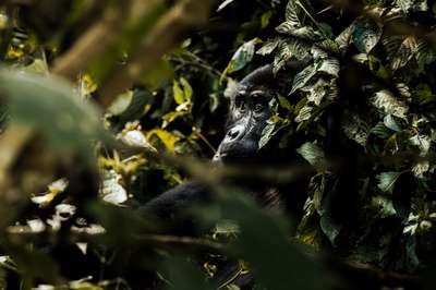
After three hours of trekking through Bwindi Forest National Park, we reached a gorilla family resting in the forest understorey. The group was peaceful and close — far closer than any description had prepared me for. One individual turned toward us, regarded us briefly through a gap in the foliage, and turned away. That moment of quiet mutual observation — the animal entirely unhurried, the forest entirely undisturbed — is what separates Bwindi from every other national park I have visited across Uganda and East Africa.
Bwindi Forest National Park is not simply an old forest with gorillas in it. It is one of the most biologically complex ecosystems on the African continent: a forest that survived the Pleistocene dry periods when most central African rainforest was eliminated, that has been occupied continuously for millennia by both wildlife and human communities, and that now sits at the centre of a transboundary conservation network spanning Uganda, Rwanda, and the Democratic Republic of Congo. During visits in January 2026, June 2026, and earlier in October 2024 when I was photographing elsewhere in Uganda, I documented what this forest means — ecologically, institutionally, and practically — from the ground up.
This page covers the forest as an ecosystem: what makes it ancient, what makes it impenetrable, which institutions protect it and under what legal framework, and how Gorilla Conservation Coffee has turned the economics of the forest boundary into a conservation mechanism. The visitor and trekking guide is at Bwindi Forest National Park: Complete Guide.
What Kind of Forest Is Bwindi, and Why Has It Survived?
Bwindi's forest is classified as moist tropical mixed forest — a category that, in Uganda, describes a relatively small number of remaining ecosystems. The defining characteristic is continuity: the forest has not been significantly cleared or fragmented in recorded history, and the evidence from pollen records and geological surveys suggests it has been forested continuously for over 25,000 years. During the Last Glacial Maximum, when temperatures dropped and rainfall in central Africa reduced dramatically, most of the region's lowland forests contracted or disappeared. Bwindi, sitting at higher elevation in the Albertine Rift highlands, retained sufficient moisture to persist — making it what ecologists call a refugium: a place where species and genetic diversity was preserved while the surrounding landscape was stripped.
The result of that survival is a forest with an unusually deep inventory of life. The park records 347 bird species — including 23 Albertine Rift endemics found nowhere else on Earth — more than 200 tree species, 120 species of mammals, and 310 butterfly species. The undergrowth is dense enough to make navigation without a path genuinely impossible in most sections, which is the origin of the "impenetrable" name used since the colonial period. Early surveyors and administrators who tried to map the forest found the low vegetation — tangled vines, knee-height ferns, dense stands of saplings and shrubs — impossible to traverse without cutting, even for small parties. The name stuck, and Bwindi Impenetrable National Park is now its official designation.
The forest spans a vertical range from approximately 1,160 metres at the valley floors to 2,607 metres on the upper ridges. This altitude gradient creates multiple distinct vegetation zones within a single protected area: moist lowland forest at the base with a high canopy; mixed montane forest on the mid-slopes; and upper montane forest and heath near the summits. The gorilla population moves across this vertical range depending on season, altitude, and food availability — which is why trek lengths vary so dramatically from one morning to the next. Trackers who enter the forest before dawn follow the path from the previous evening's nesting sites and radio back their location.
Bwindi Among Uganda's Forests: The Institutional Landscape
Uganda's remaining natural forests cover a fraction of what existed at independence. The National Forestry and Tree Planting Act governs forest management across the country, dividing forests into Central Forest Reserves (managed by the National Forestry Authority), Community Forests (held in trust by local councils), and Local Forest Reserves. National parks like Bwindi sit outside this framework under Uganda Wildlife Authority jurisdiction, but the surrounding landscape is managed under the forestry legislation — and the buffer zone between park boundary and farmland is where the Forestry Act, the Wildlife Act, and the National Environment Act converge.
Mabira Forest, in the Lake Victoria crescent east of Kampala, is the largest remaining tropical rainforest in the Lake Victoria basin at over 300 km². It supports a significant biodiversity inventory and has faced successive proposals for partial conversion to sugar cane since 2007 — each generating substantial public opposition. Mpanga Forest Reserve, 45 km² near Mpigi south of Kampala, is a smaller-scale intact forest managed primarily for research and light ecotourism. Kibale Forest National Park in western Uganda is the most comparable to Bwindi in management intensity, housing the highest density of primates of any forest in Africa and offering chimpanzee habituation experiences under the same UWA framework that governs Bwindi's gorilla permits.
Bwindi sits at the extreme end of the conservation intensity spectrum within Uganda. The park boundary is actively managed, the ranger force is comparatively well-resourced, and the gorilla habituation programme — which has run since the early 1990s — requires sustained investment in veterinary monitoring, community liaison, and inter-agency coordination. The Makerere School of Forestry and the Institute of Tropical Forest Conservation (ITFC) at Ruhija both contribute research capacity to Bwindi's management — with ITFC specifically embedded within the park boundary and conducting long-term ecological monitoring that informs UWA management decisions.
Gorilla Conservation Coffee: Protecting the Forest Boundary Through Farming
The most immediate threat to any protected forest is not poaching inside its boundaries but encroachment at its edges. When farming communities adjacent to the park find that deforestation raises their income more than conservation does, the park boundary shifts. Gorilla Conservation Coffee addresses this incentive problem directly by making coffee farming at the existing boundary economically superior to clearing additional forest.
The organisation works with smallholder coffee farmers in the communities around Bwindi — primarily in the Buhoma, Ruhija, and Nkuringo areas — paying premium prices for certified coffee while advocating for gorilla protection and sustainable land management. The premium is premised on the conservation credentials of the coffee: buyers, particularly in export markets, pay a margin for coffee they can credibly associate with a conservation outcome. That margin flows back to farmers as a direct financial signal that the existing forest boundary is worth maintaining.
The organisation also operates the Gorilla Conservation Café on Portal Road in Entebbe, opened in 2018. The café serves as both a retail outlet for the coffee and an urban ambassador for the conservation programme — a place where Ugandan consumers and international travellers passing through Entebbe can encounter the Bwindi connection before or after a visit. Coffee from Bwindi's buffer zone communities sits on the same shelf as information about the gorilla programme. The Gorilla Conservation Café model is now one of the more recognisable conservation-linked retail concepts operating in Uganda.
The economics underlying this model are simple but require sustained management to function. Premium prices only work as a conservation tool if the premium is reliably maintained and the certification credible. If the buyer network weakens or prices drop to commodity levels, the incentive to clear forest reasserts itself. Gorilla Conservation Coffee's ongoing work is therefore as much institutional — maintaining buyer relationships, certification standards, and farmer training — as it is agricultural.
Uganda's Conservation Regulatory Framework: What Protects Bwindi
Bwindi operates within a multi-layered legal and regulatory structure that has grown substantially since the early 2000s. Understanding this framework is useful not only for researchers and operators but for travellers — it explains why lodges near the park boundary behave the way they do, why waste management is a visible operational concern, and why commercial operators undergo audits that are sometimes referenced in their marketing.
National Environment Act 2019
The National Environment Act 2019 (Act No. 5 of 2019) is Uganda's primary environmental legislation. It established the National Environment Management Authority as the central body for environmental governance, mandated environmental and social impact assessments for defined categories of development near protected areas, and authorised the Minister to make subsidiary regulations on specific issues. The Act replaced the 1995 National Environment Statute and significantly strengthened compliance mechanisms and sanctions. For Bwindi, the Act creates the legal basis for requiring environmental management plans from any tourism or commercial operator working in or adjacent to the park.
Environmental Audit Regulations: S.I. 47 of 2020
The National Environmental (Audit) Regulations, Statutory Instrument No. 47 of 2020, require commercial operators in Uganda — including lodges, tourism operators, and businesses near protected areas — to conduct environmental audits at defined intervals and submit reports to NEMA. An audit assesses the actual environmental performance of an operation against its approved environmental management plan: energy use, water management, waste disposal, community impacts, and compliance with environmental conditions attached to development permits. Uganda Wildlife Authority reported that 500 hospitality establishments were inspected under this framework in 2024/25. For lodges near Bwindi, this audit process is not optional.
Waste Management Regulations: S.I. 49 of 2020
The National Environment (Waste Management) Regulations, Statutory Instrument No. 49 of 2020, govern the management, storage, transport, and disposal of all categories of waste in Uganda. For lodges and tourism facilities near Bwindi, the regulations require approved waste management plans, separation of waste streams, and proper disposal through licensed channels. Organic waste from lodges near the park boundary is particularly sensitive — improperly managed food waste near the forest edge attracts wildlife, creates habituation problems, and risks disease transmission between domestic animals, wildlife, and gorillas. The regulations translate this ecological risk into a legal obligation.
Environmental Practitioners Regulations: 2003
The National Environment (Conduct and Certification of Environmental Practitioners) Regulations 2003 establish a registration and professional standards system for environmental practitioners working in Uganda. Practitioners conducting environmental impact assessments, audits, or ecological monitoring for projects near protected areas must be registered with NEMA and meet defined competency standards. The regulations create accountability in the environmental assessment process — an assessment signed by an unregistered practitioner is not legally valid — which matters significantly when assessments are used to justify development near Bwindi's boundary.
Environmental and Social Assessment Regulations: 2020
The National Environment (Environment and Social Assessment) Regulations 2020 update and replace earlier EIA regulations, aligning Uganda's assessment process with contemporary international standards including World Bank safeguard requirements. For any significant development in or near Bwindi — a new lodge, a road improvement, a community facility — the regulations govern the scope and methodology of the assessment that must precede planning approval. The 2020 regulations introduced a more structured screening process, tiered assessment requirements based on project scale, and clearer timelines for NEMA review and decision.
Ruhija: The Research Sector
The Ruhija sector occupies the north-eastern corner of Bwindi, at higher elevation than Buhoma and in a cooler, wetter section of the forest. It is less developed for mass tourism than Buhoma — accommodation options are fewer and the infrastructure lighter — but it carries a disproportionate share of the park's scientific activity. The Institute of Tropical Forest Conservation (ITFC), a field station of Mbarara University of Science and Technology, operates from Ruhija and has been conducting long-term ecological research in Bwindi since 1991. ITFC's work covers gorilla behavioural ecology, forest phenology, bird community dynamics, and the impacts of climate change on high-altitude vegetation. Its data sets, accumulated over more than three decades, form the empirical backbone of Bwindi's management decisions.
The Ruhija Community Rest Camp is a community-owned facility offering simple cottages and a campsite — one of the more affordable accommodation options in the park and a direct revenue stream for the local community. At this altitude, the forest outside the window at dawn sounds different from Buhoma: the bird species mix shifts toward Albertine Rift endemics that require cooler, higher-altitude habitat. For birders, Ruhija is often described as the single most productive location in East Africa for Albertine Rift endemic bird species.
Nkuringo Walking Safaris, a specialised operator based near Kisoro to the south, offers multi-day walking routes that connect Bwindi to the Lake Mutanda area and the Virunga foothills. These routes cross the landscape immediately adjacent to the park and provide an experience of the Bwindi ecosystem from its edges rather than from a sector trailhead — a perspective that reveals how the park boundary interacts with the farming landscape around it.
The Virunga Conservation Area: Bwindi in a Transboundary Landscape
Bwindi does not function as an isolated island of forest. It is the largest component of a transboundary ecosystem — the Virunga Conservation Area — that encompasses Mgahinga Gorilla National Park in south-western Uganda, Volcanoes National Park in Rwanda, and Virunga National Park in the Democratic Republic of Congo. The mountain gorilla population is not divided by these borders; individuals and family groups move between jurisdictions, and a gorilla family habituated on the Ugandan side may spend part of the year in Rwanda or DRC. Conservation management of the subspecies therefore requires coordination that no single country can deliver alone.
The International Gorilla Conservation Programme (IGCP), a joint initiative of WWF, Flora & Fauna International, and the African Wildlife Foundation, provides the coordination framework. IGCP supports cross-border monitoring, harmonises gorilla health protocols across the three range states, and facilitates the joint population censuses that produce the official mountain gorilla count. The most recent census, covering the entire transboundary population, produced a count of over 1,000 individuals — the first time the species has exceeded that threshold in recorded observation. The Bwindi-specific population assessment of 2018–2020 counted 459 gorillas in the Ugandan landscape.
The Dian Fossey Gorilla Fund International operates primarily in the Virunga massif on the Rwandan and DRC sides but contributes to the broader scientific understanding of mountain gorilla behaviour and population dynamics that informs Bwindi management. Berggorilla- und Regenwald Direkthilfe e.V., a German conservation organisation, has supported gorilla conservation programmes in the Virunga region for decades, primarily through direct financial support for anti-poaching and community programmes on the DRC side where state conservation capacity is significantly weaker.
The Bwindi Mgahinga Conservation Trust (BMCT), established in the 1990s as part of the original Bwindi management framework, provides grant funding to community projects in the parishes adjacent to both Bwindi and Mgahinga. BMCT funding has supported schools, health infrastructure, and income-generating projects in communities that lost direct access to the forest when the park boundaries were formalised. The Nkuringo Conservation and Development Foundation operates similarly in the Nkuringo sector, channelling resources toward community development in exchange for community support for conservation objectives.
Uganda's National Parks: Bwindi in the Wider Context
Bwindi is one component of a national parks system that covers a range of ecosystems from the savanna of Murchison Falls in the north to the crater lakes of Queen Elizabeth in the west and the Rwenzori mountains along the DRC border. During my October 2024 visit to Murchison Falls National Park — a 3,840 km² savanna and riverine ecosystem on the Albert Nile — I documented the full range of what Uganda's national parks can offer beyond the forest experience that Bwindi represents.
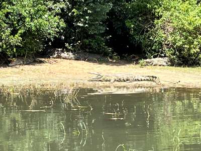
On a boat safari along the Albert Nile in October 2024, we watched Nile crocodiles from a reasonable but instructive distance — large enough that the scale of the animals was unmistakable even from the boat, and fast enough, when one slid into the water, to explain why the riparian vegetation stays so clear. The same afternoon we were close to an elephant moving through savanna grassland, its tusks visible against dark skin, its herd a few hundred metres away. These are the encounters that the savanna parks offer; they are structurally different from Bwindi — more open, more predictable, less intimate — but equally authentic as Uganda wildlife experiences.
The contrast matters for travellers building a Uganda itinerary. Bwindi offers one unique thing that no other national park on Earth replicates: a habituated mountain gorilla encounter. Everything else it offers — forest birding, primates, high-altitude landscape, community culture — exists in varying forms elsewhere. Adding Murchison Falls, Queen Elizabeth National Park, or Kibale Forest extends the ecological range of a Uganda visit without diminishing what Bwindi contributes. Most visitors who arrive with sufficient time build a triangle: Murchison in the north for savanna, Kibale for chimpanzees, Bwindi for gorillas. It is a logical circuit around the country's best-developed wildlife watching infrastructure.
Frequently Asked Questions: Bwindi Forest National Park
Related Articles
Bwindi Forest National Park: Visitor Guide
Bwindi Impenetrable National Park
Forest Ecology at Bwindi
Forest Layers and Vegetation Zones
Anti-Poaching at Bwindi
Community Revenue Sharing
Bwindi Gorillas: Conservation and Science
Bwindi Gorillas: First-Hand Trek Guide